Beidou 3 (Compass Navigation Satellite System)
The Beidou-3M/G/I satellites represent the orbital segment of the third phase of the Chinese Beidou navigation system which uses satellites in Medium Earth Orbit and Geosynchronous Orbit and is also known as the Compass Navigation Satellite System.
Beidou is already in operation for the Chinese and Asia-Pacific Area with global availability planned by 2020 when all satellites will have been launched. The China Satellite Navigation Project Center is in charge of program management.
The concept for a Chinese Navigation System was first presented in 1983. In 1989, two hosted payloads confirmed the feasibility of operating a dual-satellite regional navigation system from Geostationary Orbit. Beidou was approved as a program in 1993 to provide China with independent access to regional and global navigation, no longer relying on foreign systems like the American GPS and Russian Glonass System. Beidou is the Chinese name of the Big Dipper constellation which was used in ancient navigation to locate the North Star.
The Beidou Global Navigation system was outlined for a step-wise implementation starting with an experimental system consisting of three satellites in Geostationary Orbit, located above the Chinese territory to provide local navigation services. The second phase of the project is the deployment of operational Beidou navigation satellites to initially establish a regional navigation system before expanding to global coverage, going through different satellite modifications to keep up with technical standards. In 2020, full global Beidou coverage will be achieved.
The first generation of experimental Beidou satellites launched in 2000 (Beidou-1A and 1B) and 2003 (Beidou 1C) – all based on CAST’s DFH-3 Geostationary Bus. Once all satellites had entered station and commissioning was completed in 2004, the regional Beidou navigation system started operations, reaching an accuracy of 20 meters.
Another Beidou-1 satellite was launched into Geostationary Orbit in 2007 to ensure the constellation could tolerate one satellite failure and still remain operational in order to bridge the gap between the experimental and operational Beidou Systems.
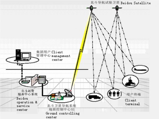
Beidou terminals were in use in the wake of the 2008 Sichuan Earthquake and have become a standard piece of equipment for Chinese border guards. The measurement scheme requires at least two satellites (accuracy increases with a third and fourth) that are in contact with a user terminal and a central ground station.
The user terminal receives a signal from one satellite and transmits a signal that is received by both satellites that relay it to the ground station where the 2D position of the user is calculated through the time delay of the two signals which can be processed into a 3D information using a topographic map in an algorithm that yields the position of the user that is then transmitted back via the encrypted satellite link. 150 users could be serviced simultaneously with this type of position retrieval.
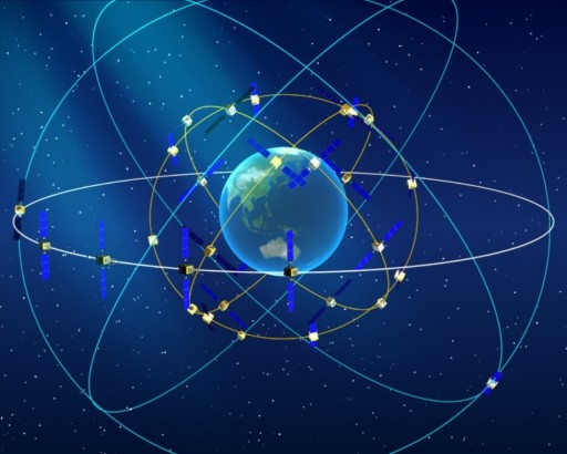
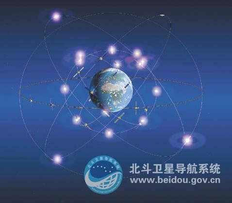
Upgrading from the experimental to the operational Beidou System, China plans to launch a total of 35 satellites – five in Geostationary Orbit to provide follow-on capability for all existing Beidou-1 systems, 27 in Medium Earth Orbit and three in inclined Geosynchronous Orbits to augment navigation accuracy.
Beidou will deliver two types of service – a free service that is open for everyone with a compatible terminal and a licensed service for the Chinese government for application in military and other purposes. The free service will provide a position accuracy of 10 meters, speed measurement as accurate as 0.2m/s and a timing accuracy of 10 nanoseconds. The restricted service will have a tracking accuracy of 10 centimeters and will include data transmitted via the signal to deliver information on the status of the system to operational users.
The first Beidou-2 satellite launched in 2007 under the designation Compass-M1 to serve as a testbed for the operational Medium Earth Orbit satellites. It entered a 21,150-Kilometer orbit from where it was used for frequency validation and signal testing.
The first Beidou-2G satellite was launched in 2009 atop a Long March 3C rocket, entering its slot to be followed by four additional satellites until 2012. Because the first BD-2G satellite failed early in its planned eight-year mission, a replacement was sent into orbit in late 2012. These satellites also use the flight-proven DFH-3 satellite bus and carry a phased array antenna for the transmission of navigation signals, an S- and L-Band dish antenna, a C-Band ranging antenna and a laser retroreflector for precise orbit determination.
In 2010 and 2011, five Beidou-2I satellites were launched atop Long March 3A rockets to enter slots in inclined Geosynchronous Orbits (55°) covering China and surrounding territories. By the end of 2011, the Beidou-2 system entered service for operators in China and surrounding territories with an initial accuracy of 25 meters that was to improve as more satellites were launched.
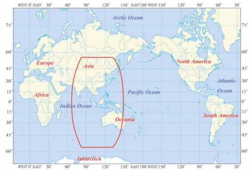
In 2012, two dual-satellite launches using the Long March 3B rocket were conducted to loft four Beidou-2M satellites into 21,520-Kilometer orbits at an inclination of 55 degrees. Once these satellites were declared operational, Beidou navigation services were made available for the Asia-Pacific Region starting in December 2012.
To expand the system to a Global Navigation Satellite System, CAST designed three different types of satellites – Beidou-3M satellites to enter Medium Earth Orbit (27 satellites), Beidou-3I in inclined Geosynchronous Orbits (3 satellites) and Geostationary Beidou-3G Satellites (5 satellites).
The IGSO and GEO satellites will be launched when the Beidou-2 satellites in these orbits reach the end of their lives while the Medium Earth Orbit constellation starts deployment in 2015 to be fully operational by 2020 transitioning from a deployment into a maintenance phase with a few launches per year like it is done for GPS and Glonass.
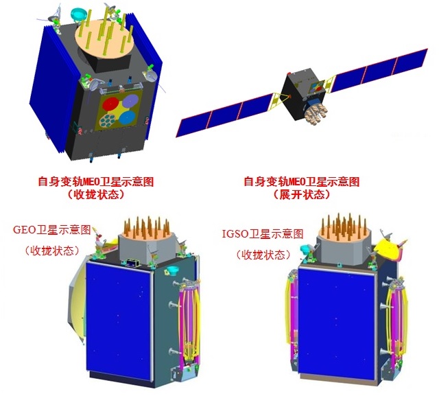
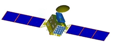
The Geostationary Beidou-3G satellites are based on the DFH-3B satellite bus provided by the China Academy of Space Technology (CAST) using heritage components from the flight-proven DFH-3 bus and expanding its capabilities by supporting more advanced payloads and reducing the overall weight of the platform. The DFH-3B bus is hexahedral in shape measuring 2.2 by 2.0 by 3.1 meters in size with a mass of 3,800+ Kilograms.
The Beidou satellites will have a mass around 4,600 Kilograms featuring two three-segment solar arrays that generate 6,800 Watts of electrical power stored in batteries and distributed to the various systems and the payload. The satellite uses state of the art navigation systems including star and Earth sensors & attitude actuators providing excellent stabilization on all three axes. Stationkeeping accuracy in Geostationary Orbit is +/-0.05 degrees.
The RDSS (Radio Determination Satellite Service) payload of the Beidou-3G satellites consists of a high-power S-Band transponder, a low-noise L-Band amplifier and frequency generator, a phased array L-Band antenna, an L-/S-Band dish antenna and a C-Band antenna. RDSS uses the original position retrieval including the central ground station to provide compatibility of the new system with existing Beidou-1 terminals. The RNSS (Radio Navigation Satellite Service) payload uses ultra stable timing signals delivered by an atomic clock to generate L-band signals that are transmitted through an antenna array.
RNSS also includes an L-band uplink receiver and laser reflector for orbit determination. This payload works on the same principle as GPS and Galileo using similar frequency bands.
The five Geostationary Satellites of the Beidou constellation reside in the following orbital slots: 58.75ºE, 80ºE, 110.5°E, 140°E and 160°E. Documentation shows that each GEO satellite weighs 4,600 Kilograms while the IGSO satellites weigh 4,200kg and only generate 6,200 Watts of power.
The three satellites in inclined Geosynchronous Orbits are nearly identical to the Beidou-3G spacecraft using the same bus and payloads, operating from orbital inclinations of 55° with a 120-degree spacing in the right ascension of ascending node.
The 27 Beidou-3M satellites deployed to a 22,000-Kilometer Medium Earth Orbit inclined 55° are using a newly developed Navigation Satellite Bus that is more compact than the large DFH-3 satellite bus but still uses a number of heritage components to match DFH-3 capabilities & reduce risk. The three-axis stabilized satellites have a launch mass of 1,014 Kilograms including 280 Kilograms for the navigation payload, measuring 2.25 by 1.0 by 1.22 meters in size.
Two power-generating solar arrays deliver 1,500 Watts of electrical power for the satellite systems and navigation payload. The satellites only use the RNSS communications payload. The MEO segment operates in a 55-degree orbit with three planes that each host nine satellites to guarantee global coverage.
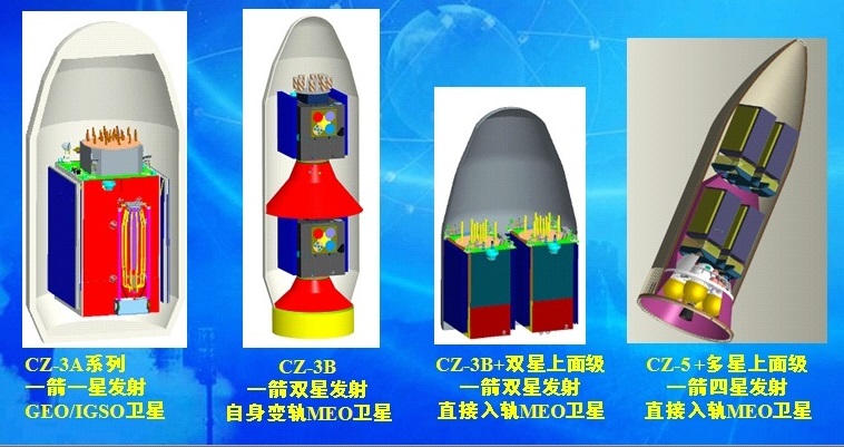
The Beidou-3M satellites can be launched as single spacecraft atop the Long March 3C rocket with YZ-1 upper stage, as pairs on CZ-3B/YZ-1 or four at a time on Long March 5 plus appropriate upper stage.

The Beidou RNSS operates like the European Galileo and American GPS, also using similar frequency bands. The rubidium atomic clocks provide the precise timing solutions needed for the calculation of the time delay from the moment the signal is sent and the arrival at the receiver which in turn allows the calculation of the distance to the satellite. Three simultaneous distance measurements to three different satellites are needed for the receiver to calculate its precise position.
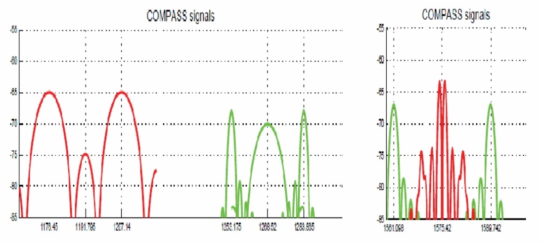
Beidou uses eight different signals in four bands all in the 1,100 to 1,600 MHz range: B1 (Carrier Frequency: 1561.098MHz / Bandwidth: 4.092MHz / Modulation: QPSK), B1-2 (1589.742 / 4.092 / QPSK), B2 (1207.140 / 24 / QPSK), B3 (1268.520 / 24 / QPSK), B1-BOC (1575.42 / 16.368 / MBOC), B2-BOC (1207.140 / 30.69 / BOC 10,5), B3-BOC (1268.520 / 35.805 / BOC 15,2.5), L5 (1176.450 / 24 / QPSK).
The ranging code is a Pseudo-Random Noise (PRN) sequence of 0s and 1s that allow the receiver to determine the signal’s travel time. Data signals include binary-coded messages containing information on the satellite ephemeris (position and velocity), clock bias parameters for error correction, satellite health status and other complementary information.